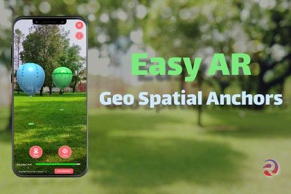
Easy AR Geospatial Anchors is an innovative geospatial app designed to revolutionize how users interact with the physical world through Augmented Reality (AR). This powerful application allows users to create, manage, and experience AR content tied to specific real-world locations. With the ability to anchor digital objects in precise geographical coordinates, Easy AR Geospatial Anchors bridges the gap between virtual and physical spaces, offering enhanced navigation, immersive experiences, and contextually relevant information.
Features of Easy AR Geo Spatial Anchors Pack
- Place and retrieve AR content in given geo location coordinates precisely
- Editor and runtime AR object placement
- Automatic lights & reflections
- No coding skills needed
- Compatible with IOS and Android
- Free demo experience (Balloon Hunt)
Third-Party Assets
- Asset uses Arrow-loose.wav under Creative Commons 0
- Asset uses Balloon-pop-5.wav under Creative Commons 0
Other Creations by Render Island
- Ancient Village Pack
- Christmas Seasonal Pack
- Ruined Fantasy Island
- Visual Effects & Shader Asset Pack
- Easy AR : Make Awesome AR Apps Without Coding
- Sci-Fi Police Pack
- 3D UI Elements Pack Vol:1
- Halloween Seasonal Pack
- Easy AR Spatial Anchors with Azure Cloud
- Easy AR Mini Games pack
Documentation can be found here
https://render-island.gitbook.io/easy-ar-geospatial-anchors
Need support?
- We are happy to help you on our DISCORD channel.
Follow us on Social
Sign in to offer a newer .unitypackage for this asset. Uploads are reviewed before they appear.